Showing posts with label The Bruce. Show all posts

Sunday, September 24, 2017

The Fishing Islands

On the shores of Lake Huron, part of the South Bruce Peninsula
The mainland of the Peninsula opposite the Islands is mostly low lying and sandy,forming in several places small sand-dunes. 

The area between the shore and the Islands has been filled in with sand, leaving large areas of shallow water, miles in extent, over which people may walk or     drive. At low water great stretches of sand show their rippled, yellow surfaces; and some of the islands become attached to the mainland or to each other. 
So it is, that a definition of an island at Oliphant is “a piece of land with    sand all around it.” 

The Islands in all number over seventy and vary in size from a mere shoal of     flat rock with a few currant bushes growing thereon, to the largest, Cranberry,       containing one hundred and twenty-four acres.
Just north of Hawksnest Island, a picturesque spot, at times a part of the       mainland and at times an island, the “Diagonal Road” from Wiarton enters by way  of Marie Street. The town-plot of Oliphant, laid out at the time of the Rankin      Survey in 1855, reaches from this street northward one mile. Here it was expected that a commercial centre would have sprung up, a hope which has never been real- ized and which has doubtless long since passed away. Point au Rock is a small    peninsula stretching outward from the centre of the town-plot. Westward from it  is a marshy formation of reeds, through which the far-famed Gut Channel passes,  forming the  key of inside navigation between the North and South. The name is   far from being attractive, but it is time-honoured, and will doubtless remain    for all time.
In the few years of Oliphant’s existence as a summering place, it has grown up   rapidly. Pretty little summer houses have been erected here and there along the  shore and islands, some hidden amongst the ever-greens, 
others out in the open sunshine, some on the well protected islands, and others away out where the
great storms of Lake Huron break and almost tear away their moorings. In all there are more than a hundred and fifty camps scattered over the region, and there is scarcely a town in Western Ontario that is not represented in their population.
We may sum up Oliphant’s     varied charms in just a      few  words. It is a place         romantic, historic, and      beautiful; it has many       islands, channels, and by-   ways to explore amongst; it  has some of the finest bass  fishing in the Great Lakes;   it has bathing that for      warmth of temperature can    scarcely be equalled; it     has splendid boating —       sailing, rowing, paddling,   and motor-boating; 
it has an annual Regatta where strength and skill of body and craft are displayed to advantage; it has three athletic grounds, one on mainland, one on Rabbit      Island, and one on Frog Island, the scenes of many ball games and field sports;  it has a church, a government dock now lighted, a spring that never runs dry, and may we add, a post office which brings, let us trust, many joys; it has never had a fatality or serious accident, to mar its sense of pleasure; and above all its  inhabitants are of a high standard of citizenship, from which emanates a spirit  of helpfulness and sociability so necessary in the life of people seeking health, comfort, and happiness. 
The first gathering of the campers was in the form of a picnic held in 1903 at Cranberry, the home of Mr. and Mrs. Cross. The next year it was held at Hawksnest Island. In 1907 the picnic was changed to a regatta and held at the Government Dock built the year before. The Regatta has proved an extremely popular annual event in which aquatic sports are keenly contested by all classes of campers old and young.

OLIPHANT AND ITS ISLANDS • LAKE HURON 

HISTORICAL AND DESCRIPTIVE SKETCHES 

WRITTEN BY IRENE MONKMAN AND ROY FLEMING 

COPYRIGHT, 1912 
A walk around the Oliphant Government Dock and Marina for Restless Jo
accompanied by a 1912 description of the area

Wednesday, September 20, 2017

Wiarton Willie

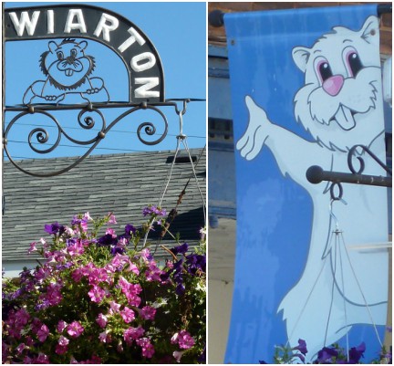
 It has just been announced that Wiarton Willie, the 13 year old albino groundhog, has died. He lived a long life, being well cared for in his enclosure at the Bluewater Park. Wiarton Willie was an albino groundhog whose image is everywhere in this small town on the Bruce Peninsula. And every year, on Groundhog Day, the town welcomes hundreds of people who come to meet him and enjoy the festivities as he is brought out of hibernation to see - or not - his shadow and give his forecast whether there will be six more weeks of winter. 
there will be a memorial service and funeral procession on September 30th after which his understudy, Wee Willie, will take up the mantle of Chief Prognosticator.

sharing with signs, signs

Monday, September 18, 2017

following the PE&NS RR


At this time of year (after Labour Day) the beach at Port Elgin is very quiet. 
Kids are back in school and most of the tourists have gone.
Even Lake Huron was quiet and calm.


the gazebo where weekly summer concerts are held is a perfect place to sit and read out of the sun if you have a lawn chair with you, which you will also need for those Sunday evening concerts.


the little steam train sits quietly waiting for the weekend when it will run through a 1.6km trip on the Port Elgin and North Shore Railroad around the harbour and park, blowing its whistle along the way. I can hear it from the cottage where I am staying. it has been running for decades, and there are plans to have the station renovated and upgraded, and possibly moved to the North Shore Park at the other end of the waterfront, which led to false rumours that the town might scrap the train altogether.
in the background you can see the newly built Edinburgh Club, the first luxury condominium to be built on the waterfront. there are still 2 units left, according to a sign on the other side.


only three of the boats at the marina have been dry docked that I could see. and, glancing at the petrol pumps, I noticed the price is .20 cents more expensive than for autos (at $1.38 litre)


some Canada Geese were lazily drifting in between the boat docks, 
with others heading in to join them
until something spooked them 
(wasn't me, I'm sure!) and they suddenly all took off
there is an open area between the harbour and the park where this majestic willow takes pride of place. see how I cleverly included the house with my favourite upstairs sunporch? just for scale, of course.
the train tracks are that line in front of the willow
further down, a walking trail takes you through the North Shore Park where you will cross the narrow gauge of the railway near where it turns around
and, finally, another resting spot to view the sunset. 
the water is still at a high level.
from there, the trail continues on ...
(that is Chantry Island Lighthouse in the distance)
sharing with Jo's Monday Walk
and Our World Tuesday
the first pictures were taken in the early morning, the last seven in the late evening

Tuesday, August 29, 2017

an old anchor

Oct 10, 1907 two schooners wrecked here last Monday night, the Erie Stewart and Ontario
crew get two boats from island dock, reach lighthouse
In 1910, the ONTARIO was running before a strong gale, she had a deck-load of bailed hay, straw and shanty supplies for the northern camps and was heading for the shelter or Chantry Island harbour of refuge just below the town of Southampton. Ahead of her was the schooner ERIE STEWART, also running for shelter. It was dark and blowing and Capt Granville could not see what happened, but the ERIE STEWART poked her Jibboom through the little range light on the end of the pier, and knocked the light-house down, all Capt. Granville knew was he could not pick up his range to get under the shelter of Chantry Island, so he tried to get the ONTARIO into the shelter of the mouth of the Saugeen River, around which Southampton clusters. The schooner was under small sail at the time, only the staysail being set, and that being "squatted" or lowered somewhat so as to reduce its area. On nearing the river mouth the wind shifted and a gust came off shore. The ONTARIO lost headway and piled up in the breakers on the shore south of the present piers, and that was where her anchor was recovered in the dredging operations. 
(from the Toronto Telegram)

Looking out over Lake Huron
the range light at Southampton
Chantry Island Lighthouse
approximately 1km from  the shore of Southampton


a little maritime history for Tuesday's Treasures

Monday, November 2, 2015

Tobermory

Following last week's walk to the caves, I drove on further to spend the rest of the afternoon in Tobermory.


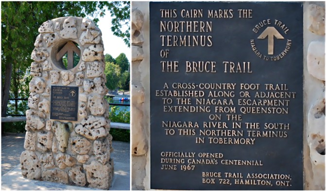
Tobermory is the end of the road. It's the farthest point on the Bruce Peninsula and the Niagara Escarpment and is the end terminus of the Bruce Trail, an almost 900km hiking trail that starts in Niagara.
It's also a seasonal town that pretty much closes down during the winter months but is always packed with campers and tourists during the summer.
This sign is new, and like in a shopping mall it lists everything you need to find on the few streets.  And, surprisingly for a non-shopper, I always quite enjoy poking around in all of these shops and galleries. There is a nice complement of touristy and general merchandise for sale.
I had to chuckle at the LCBO (our government run liquor store) being listed under 'amenities' rather than 'shopping'.

As you walk into town, straight ahead is Little Tub Harbour
where on the left hand side you can pick up one of your boat tours
and over on the right hand side are more shops plus the walking trail


and there, not quite able to hide, is the Chi Cheemaun, taking on cars to ferry over to Manitoulin Island – a two hour journey. I took the opportunity to find a bench and wait for it to leave. 


It was a bit of a wait (the ferry can hold up to 240 vehicles) but as it was so hot, somewhere around 40C, I  was extremely happy to just sit and watch.
okay, sit and take dozens of pictures. I was ridiculously pleased at the timing.
Chi Cheemaun means Big Canoe in Ojibway.
some of these bobbing heads are people on a scuba dive lesson. diving is a big thing here - lots of shipwrecks, and even underwater caves
Let's turn around and head back towards town
across the road we find this guest house, The Lightkeepers Cottage
a sculptural bench with attached planter for Jude 
(just because)
the back is in the shape of Bruce County.
and even sculptural rail posts – each one is ruggedly individual
and just beyond is the cairn
Jo may end her walks with a refreshing cup of tea, but this is where I was headed
a couple of doors down, for Anabel, is the library
more shops and an art gallery tucked in the corner
seeking shade wherever you can!
as I was walking back to my car, I noticed a new building
 will replace this older cottage style one. 
 not quite as charming, but I'm sure the space is sorely needed.

In case you're wondering, the Flowerpot is a type of sea stack on an island about 6km away. They are what is left of a cliff after being battered by rain, wind, waves, ice, and time. There are currently two of them on the island, and they look like what is at the gateway sign (first picture).

if you so desire, amble on over to restlessjo to find other walks from around the world